I’ve sat through my fair share of city council and planning commission meetings. You know the ones. They’re usually in a beige-colored room with bad lighting, and someone is presenting a series of incredibly complex architectural drawings that look more like a bowl of spaghetti than a neighborhood plan. The jargon flies fast: FARs, zoning overlays, setbacks, variances... and by the end, most residents are more confused than when they walked in. They just want to know what that new six-story building is going to look like from their kitchen window.
It’s a communication breakdown as old as city planning itself. And it’s why my ears perked up when I first heard the name Laneform. It sounds sleek, modern, and solution-oriented. So, like any good SEO and tech nerd, I went digging.
The concept I uncovered is, frankly, something the world of urban development desperately needs. But what I actually found at Laneform.com was… well, a parked domain page from Namecheap. A bit anticlimactic, I’ll admit. But this doesn’t mean it’s a dead end. It often means we're looking at the blueprint of something new, a tool in its infancy. And the idea behind it is too good not to talk about.
Visit Laneform
So, What is Laneform, Anyway?
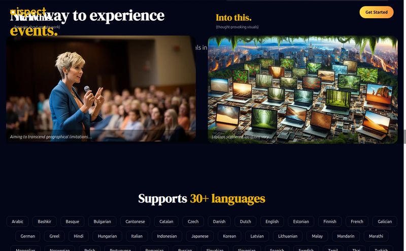
From what I've gathered, Laneform aims to be a platform for urban planners, developers, and civic leaders. The goal? To stop talking in blueprints and start communicating in pictures. The core idea is to create conceptual, photorealistic imagery of proposed projects and then guide community members through an engaging visual survey.
Think about that for a second. Instead of a 200-page PDF report on a new transit line, imagine the city sends out a link. You click it, and you're taken on an interactive tour. You see mock-ups of the new stations, you can toggle between different design options for the park next door, and you can drop a pin to say, “Hey, this crosswalk feels unsafe,” or “We need more bike racks here.” It transforms community feedback from a chore into an actual conversation.
Why Visuals Are a Game-Changer in Urban Planning
For years, the biggest hurdle in getting public buy-in for development projects has been the knowledge gap. It's not that people don't care; it's that they can't possibly be experts in municipal code. A tool like Laneform acts as a translator. It turns abstract data and complex plans into something tangible and immediate.
Bridging the Gap Between Planners and People
This is about more than just pretty pictures. It’s about building trust. When residents can clearly see what’s being proposed, they feel respected and included. It can help diffuse the knee-jerk “Not In My Backyard” (NIMBY) reaction that often stems from fear of the unknown. When you replace fear with a clear, realistic image, you can have a much more productive discussion about the actual merits and drawbacks of a project. I’ve always felt that most public opposition comes from a place of poor communication, not pure obstructionism.
A Picture's Worth a Thousand Zoning Ordinances
Let's be honest, seeing is believing. Describing a building as having a “45-foot height with articulated facade elements” means nothing to most people. Showing them a realistic rendering of that exact building on their street? Now that gets a real reaction. It allows for specific, useful feedback. People can comment on the materials, the scale, the way it interacts with the sidewalk. This is the kind of granular, street-level insight that planners can actually use to make projects better for everyone.
The Laneform Toolkit: What's Under the Hood?
Based on the available information, Laneform seems to boil down to two primary features:
- Conceptual Imagery Creation: This is the engine of the platform. It gives planners the power to generate visual representations of their projects. I imagine this would be more accessible than high-end architectural software, designed for communication rather than construction.
- Interactive Visual Surveys: This is the community-facing part. It’s not just a gallery of images; it's an interactive experience designed to solicit and organize feedback in a structured way. This is critical for turning a flood of comments into actionable data.
The Good, The Bad, and The To Be Determined
No tool is a magic wand, and even from this early stage, we can see the potential peaks and valleys. I like to think of it as a balance sheet of possibilities.
The Upside of Using Laneform
The potential benefits are pretty clear. You’re looking at a serious boost in community engagement and a much clearer public understanding of development. By gathering feedback directly tied to visuals, planners can get more specific, actionable insights. In my world of SEO and digital traffic, this is gold. A city that uses a tool like this for a major project could see a huge spike in positive local search sentiment and engagement on its own web properties, which is a massive win for public perception.
Potential Hurdles to Consider
On the flip side, there are some real challenges. Creating good visual representations isn't easy, and it likely requires a certain level of technical skill. Bad renderings can be just as misleading as no renderings at all. The quality of the output will be limited by the quality of the data going in—garbage in, garbage out, as they say. And there’s the classic community feedback problem: are you only hearing from the loudest voices, or are you getting a true cross-section of the community? That’s a tough nut to crack, and a platform on its own cant solve it entirely. It has to be paired with good old-fashioned outreach.
What's the Price Tag on Better Cities?
This is the million-dollar question, isn't it? As of now, with a parked domain, pricing for Laneform is completely up in the air. There is no pricing page, no public information. My professional guess? We’ll probably see a Software-as-a-Service (SaaS) model. I’d bet on tiered pricing based on the size of the municipality, the number of active projects, or the number of survey respondents. It would make sense to have a plan for small towns, another for mid-sized cities, and an enterprise solution for large metropolitan planning organizations or major developers. But for now, we'll have to wait and see.
My Final Thoughts: A Promising Blueprint
Despite the website being an empty lot for now, the concept of Laneform is incredibly exciting. It addresses a fundamental, persistent pain point in one of the most important sectors of our society. Building the places we live is a team sport, but for too long the public has been left on the sidelines because they couldn't understand the playbook.
If Laneform can deliver on its promise—if it can create a tool that is both powerful for planners and genuinely accessible for residents—it could do more than just streamline feedback. It could fundamentally change the tone of urban development from one of conflict to one of collaboration. And that’s a future I’m eager to see built.
Frequently Asked Questions about Laneform
- What exactly is Laneform?
- Laneform is a proposed digital platform designed to help urban planners and developers create visual representations of their projects and engage the community through interactive surveys. The goal is to make complex plans easier for the public to understand and provide feedback on.
- Who is the target audience for Laneform?
- It seems to be built for professionals involved in urban development. This includes city and municipal planners, private land developers, architects, and civic leaders who need to communicate project plans to the public.
- Is Laneform available to use now?
- Currently, it does not appear to be publicly available. The official website, laneform.com, is a parked domain, which suggests the platform is still in a development or pre-launch phase.
- How does Laneform improve on traditional community meetings?
- It replaces or supplements traditional meetings by moving the conversation online to a visual-first format. Instead of just hearing about a plan, residents can see and interact with it, allowing them to provide more specific, contextual feedback at their own convenience.
- What are the main potential drawbacks of a tool like Laneform?
- The main challenges would be the need for technical skill to create accurate visuals, the risk of feedback not representing the entire community, and the fact that the platform's effectiveness is tied to the quality of the planning data used.
- How much will Laneform cost?
- There is no official pricing information available yet. It is likely to be a subscription-based service (SaaS) with different pricing tiers depending on the user's needs, such as the size of the city or the number of projects managed.
Reference and Sources
- Project for Public Spaces (PPS) - A nonprofit organization dedicated to creating and sustaining public places that build stronger communities.
- American Planning Association (APA) - A professional organization for urban planners in the U.S. that provides resources on community engagement and best practices.
- Laneform Official Website (Note: Currently a parked domain as of this writing).