I’ve been kicking around the SEO and tech space for a while now, and I’ve seen my fair share of 'game-changing' AI tools. Some are genuinely brilliant. Others… well, let's just say they're a solution looking for a problem. So, when I stumbled upon Rasterscan, a tool that claims to automatically recognize and digitize floor plans from blueprints and even hand-sketches, my curiosity was definitely piqued.
For anyone in architecture, real estate, or construction, you know the pain. You get handed a faded blueprint from 1982, complete with coffee stains and cryptic notes, or a sketch on a napkin (we’ve all been there), and your job is to turn that into a clean, usable digital format. It’s a tedious, eye-straining process. It’s the digital equivalent of archeology, carefully tracing lines and hoping you get it right. Rasterscan promises to kill that process. But does it deliver?
So, What Exactly Is Rasterscan?
At its core, Rasterscan is an AI engine designed for one specific, but very tricky, task: looking at an image of a floor plan and understanding what it sees. It’s not just making a copy; it’s interpreting the image. It uses some pretty sophisticated tech—the website mentions deep learning models and image processing algorithms—to identify walls, doors, windows, and other symbols.
Think of it like this: you can show it a messy architectural drawing, and instead of you having to manually trace every wall in a CAD program, Rasterscan’s AI does the heavy lifting, outputting a structured, digital version. The promise is huge. It could take hours, sometimes days, of manual work and condense it into minutes. That’s the kind of efficiency that makes business owners and project managers sit up and pay attention.
How Does This AI Magic Actually Work?
The concept is straightforward. You feed the system an image—a scan of a blueprint, a photo of a drawing, or even a rough hand-sketch. The AI gets to work.
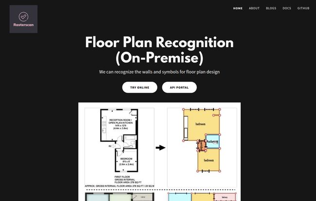
The 'before and after' shot on their homepage is pretty compelling. On the left, a standard, somewhat cluttered apartment blueprint. On the right, a clean, color-coded, and simplified digital plan. All the key elements are there: walls are solid lines, rooms are labeled, and furniture is represented by simple blocks. It's the kind of clarity you wish every project started with.
Visit Rasterscan
This isn't just a simple filter. The AI has been trained on countless floor plans to recognize the patterns. A break in a line isn't just a gap; it's a doorway. A specific cluster of lines is a window. It’s pattern recognition on an expert level, like having a junior architect on call 24/7 who runs on code instead of coffee.
The Features That Caught My Eye
Beyond the main function, a few things stood out to me as particularly interesting for professionals.
From Sketch to Digital Structure
The fact that it handles not just clean blueprints but also hand-sketches is a big deal. Blueprints are one thing, but translating a freehand drawing from a client meeting into something tangible is another level of difficulty. This flexibility means it can fit into the workflow at different stages, from initial concept to final documentation. It’s a very practical feature.
Customization and Getting It to Play Nice with Others
Rasterscan isn’t just a black box. They explicitly offer customization and integration support. This is critical. No serious business wants a tool that doesn’t integrate with their existing software stack. The ability to connect this via an API to your internal project management or design software is what turns it from a neat gadget into a genuine workflow enhancer. I’ve seen too many great tools fail because they lived on an island; Rasterscan seems to understand the need to build bridges.
Keeping Your Data Close with an On-Premise Solution
For many larger companies, especially in architecture and development, project plans are highly sensitive intellectual property. Uploading them to a third-party cloud service can be a non-starter due to security policies. Rasterscan offers an “on-premise” solution, which means the software can be installed and run on a company’s own servers. This is a massive plus for enterprise clients, giving them full control over their data.
My Honest Take on Rasterscan: The Good and The Puzzling
Alright, let's get down to it. No tool is perfect, right? Here’s my breakdown of what I love and what leaves me with questions.
On the one hand, the potential for efficiency is undeniable. The accuracy, based on their examples, seems quite high. Taking a manual, error-prone task and automating it is a clear win. It saves time, which saves money, and reduces the chance of human error when digitizing plans. For a high-volume real estate agency or a busy architectural firm, the cumulative time savings could be enormous.
However, there are a few things that give me pause. The biggest one? The pricing is a complete mystery. I scoured the site, looking for a pricing page. Nada. I even did some URL guessing games, trying `/pricing` and `/plans`. This led me to a friendly, but unhelpful, 'Page Not Found' error. This isn't uncommon for B2B or enterprise-focused software that uses a 'contact us for a quote' model, but as someone who values transparency, it’s a bit of a pet peeve. You want to know if you're in the right ballpark before you engage with a sales team.
Another point is the lack of specific accuracy metrics. They say it's accurate, and the examples look good, but I’m a data guy. I’d love to see some numbers—like a 98% accuracy rate on wall detection or something similar. And, of course, the output quality is always going to be dependent on teh input quality. A super blurry, low-resolution photo of a sketch is going to challenge any AI. It’s the classic 'garbage in, garbage out' principle. This isn't a knock on Rasterscan specifically, but a reality of the technology.
Who Is Rasterscan Really For?
So who should be bookmarking the Rasterscan site?
- Architectural Firms: To quickly digitize legacy plans or convert initial concept sketches into a base for CAD work.
- Real Estate Developers & Agents: For creating clean, easy-to-read floor plans for marketing materials or property listings from old county records or simple sketches. This is huge for improving Zillow or Redfin listings.
- Property Management Companies: To standardize the floor plans for a large portfolio of buildings, making space management and renovation planning much easier.
- Construction Companies: To verify plans or quickly generate digital versions for on-site use on tablets and other devices.
Basically, if your job involves looking at a floor plan and wishing it were a neat, editable file, this tool is aimed squarely at you. The on-premise option makes it especially suitable for larger organizations with strict data governance rules.
Frequently Asked Questions About Rasterscan
- Is Rasterscan a standalone software or an API?
- It appears to be both. You can test the service through their online portal, but the core offering for businesses seems to be an API for integration and an on-premise solution that you can host yourself.
- Can Rasterscan read handwritten notes on a floor plan?
- The primary focus is on recognizing structural symbols like walls, doors, and windows. While advanced OCR exists, it's not listed as a primary feature. It would likely ignore or try to interpret handwritten notes as part of the drawing itself. Customization might allow for this, however.
- What kind of integration support is offered?
- They explicitly mention providing integration support. This typically means they offer documentation and developer assistance to help your tech team connect the Rasterscan API to your existing software, like a CRM, CAD program, or project management platform.
- Is there a free trial for Rasterscan?
- The website has a "Try Online" button and an "API Portal," which suggests there's a way to test the technology, likely with some limitations. For a full-fledged trial, you would probably need to contact them directly.
- How secure is my data with the on-premise solution?
- Very. With an on-premise solution, the software runs entirely within your company's own IT infrastructure. Your floor plan images and data never leave your servers, giving you maximum control and security.
My Final Verdict on Rasterscan
So, where do I land on Rasterscan? I’m genuinely optimistic. The problem it solves is real, persistent, and a major source of inefficiency in several big industries. The tech seems solid, and their focus on business needs like integration and on-premise security shows they understand their target market.
It’s not a magic wand—you still need to provide it with decent-quality images—and the lack of public pricing is a hurdle I wish they’d clear. But as a specialized tool for turning visual chaos into digital order, Rasterscan is incredibly promising. In the ever-growing world of PropTech, this is exactly the kind of focused, problem-solving AI that moves an industry forward. It’s definitely one to watch.
Reference and Sources
- Rasterscan Official Website: https://rasterscan.com/
- Forbes: "The Rise Of PropTech: How Technology Is Transforming The Real Estate Industry"
- Autodesk: "What is AI in Construction and How is it Used?" https://www.autodesk.com/redshift/ai-in-construction/