Farming, land management, whatever you want to call it—it has always been a bit of a gamble. You’re betting against the weather, the market, and the mysterious whims of the very soil beneath your feet. For generations, the best tools we had were experience, intuition, and a whole lot of hope. My grandpa used to say you could smell rain coming. Me? I can barely keep a basil plant alive on my windowsill.
But the game is changing. Fast. We're in an era where data is the new soil, and the biggest tractor you can own might just be an algorithm. The idea of using satellites to look at crops isn't brand new, but we’re now moving beyond simple green-and-brown maps. We're talking about using artificial intelligence to perform a deep, diagnostic check-up on your land from hundreds of miles up. And that's where I stumbled upon a platform called Cybertiks.
As someone who spends their days neck-deep in SEO, traffic, and digital trends, I get a little jolt of excitement when I see a company trying to solve a real, tangible, boots-on-the-ground problem with seriously advanced tech. So, I decided to pop the hood and see what Cybertiks is all about. Is it just another shiny SaaS tool, or is it genuinely a glimpse into the future of sustainable agriculture?
So, What on Earth is Cybertiks?
In the simplest terms, Cybertiks uses AI to analyze satellite imagery of your fields. Think of it less like Google Earth and more like a remote MRI for your soil. It’s designed to give farmers, agricultural corporations, and even NGOs real-time, actionable insights without having to send a human out to take a thousand soil samples.
Their big pitch revolves around two of the hottest topics in the industry right now: sustainable agriculture and carbon farming. With growing pressure for eco-friendly practices and the rise of carbon credit markets, being able to prove—with data—that your land is healthy and sequestering carbon is becoming a massive deal. Cybertiks positions itself as the tool to provide that proof.
How Cybertiks Turns Satellite Photos into Actionable Data
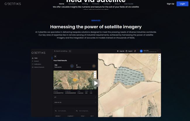
This isn't just about pretty pictures. The magic, or rather the science, is in the interpretation. The platform’s workflow seems straightforward enough:
- Define Your Turf: You start by outlining your field on a map. You can either draw it directly or upload a file like a KML. Simple.
- Travel Back in Time: The system then pulls historical satellite data for that specific plot of land, giving you a baseline.
- Stay in the Loop: From there, it monitors your field’s status, with the website saying you get new results every 7 days. That's a pretty frequent update cycle.
- See What the AI Sees: Finally, you get to view and visualize the results. They boast about resolutions up to 10cm, which is impressively detailed.
Visit Cybertiks
At the heart of this is what they refer to as QSIS (Quantitative Spectroscopic Imaging System) and their AI models. Fancy words, but the concept is cool. Every element and compound reflects light in a unique way, creating a sort of 'spectral signature.' The AI is trained to read these signatures from the satellite data to classify and quantify what’s in the soil. It’s less about seeing the dirt and more about reading its chemical makeup from space. Wild stuff.
The Core Features That Caught My Eye
Looking through their offerings, a few things really stood out to me as potential game-changers for the right user.
AI-Powered Soil Analysis from a Distance
The ability to analyze soil remotely is huge. It translates to massive savings in time, labor, and fuel. Instead of reactive problem-solving (“why are the crops in this corner yellow?”), it allows for a proactive approach. You can spot a potential nutrient deficiency or soil health issue before it becomes a visible, and costly, problem. The promise of new data every week means you're not working off last season's information; you're making decisions based on what’s happening right now.
Carbon Farming and Capture Metrics
I think this is their killer app. The carbon credit market is exploding, but it’s built on trust and verification. A farmer can say they’re using regenerative practices, but a company buying carbon offsets needs proof. Cybertiks aims to provide precise, verifiable metrics on how much carbon your soil is holding. This could be the key that connects sustainable farming practices directly to a new revenue stream. It helps with getting those all-important certifications that make carbon credits legitimate.
Mineral and Element Detection
This goes way beyond the basic N-P-K (Nitrogen, Phosphorus, Potassium) analysis. The platform claims to detect the presence of a wide range of minerals and elements. For high-value, sensitive crops, this level of detail could be the difference between a bumper crop and a failed one. It could also be used for environmental monitoring to detect potential contaminants. It’s a level of granularity that was once reserved for expensive, time-consuming lab tests.
The Good, The Bad, and The 'Contact Us for Pricing'
No tool is perfect, right? Here’s my breakdown of the highs and the potential lows from what I've gathered.
The Upside
The sheer convenience of remote analysis for anyone managing large or multiple properties can’t be overstated. The platform’s ability to integrate various data sources means you’re getting a more holistic picture. And the focus on providing tailored solutions for different groups—from a hands-on project manager to a data-driven NGO—is smart. It’s not a one-size-fits-all tool, and that's a good thing.
Potential Hurdles
Alright, let's talk about the limitations. Their own info mentions a precision limit of 10 square meters for mining detection. Now, that's for a very specific use-case and is actually pretty decent, but it's important to understand the resolution for your specific need. It's not magic. Also, the platform relies on satellite and drone imagery, which means a week of heavy clouds could delay your data. It's the Achilles' heel of any remote sensing tech, and it's just a reality to plan around. And then there's the price...
Ah yes, the classic B2B SaaS mystery. There's no pricing page. You have to contact them for a quote. On one hand, I get it. The solution is likely customized based on acreage, desired metrics, and integration needs. On the other hand, it's a bit of a barrier. It gives off that faint 'if you have to ask, you can't afford it' vibe, though it’s probably more about configuring a complex sale. Still, I always prefer transparency.
Who is This Really For?
After digging in, I don't think Cybertiks is for the hobby farmer with a few acres out back (like my sad tomato patch). The investment in time and, presumably, money points toward a more professional audience. I see a few ideal users:
- Large-Scale Agricultural Operations: Think corporate farms with thousands of acres across different locations. The efficiency gains from remote monitoring are massive here.
- Carbon Farming Investors & NGOs: Any group that needs to monitor, verify, and report on the carbon sequestration of a piece of land. This is their verification engine.
- Agricultural Consultants: A consultant could use this to manage a portfolio of clients, offering a high-tech, high-value service that sets them apart.
My Final Thoughts
Cybertiks is definitly an ambitious platform. It’s sitting right at the intersection of AI, big data, and a genuine, global need for more sustainable land use. It moves the conversation from guesswork to data-backed decisions. Is it going to replace a farmer's intuition completely? No. But it could become an incredibly powerful tool in their toolbox.
It represents a shift from simply working the land to truly understanding it on a chemical level, from anywhere in the world. And in a future where efficiency and sustainability are no longer optional, that's a powerful proposition indeed.
Frequently Asked Questions About Cybertiks
- 1. What is Cybertiks in a nutshell?
- Cybertiks is a technology company that uses AI and satellite imagery to provide detailed analysis of agricultural land. It focuses on soil health, carbon capture, and mineral content to support sustainable farming and land management.
- 2. How often is the field data updated?
- According to their website, the analysis and results for your monitored fields are updated every 7 days, providing frequent and timely insights.
- 3. Is Cybertiks a good fit for small, family-owned farms?
- While the technology is powerful, it seems best suited for larger agricultural operations, consultants, or organizations managing significant acreage due to the scale of data and likely cost structure. A smaller farm might not see the same return on investment.
- 4. How accurate is the data from Cybertiks?
- The platform boasts a visual resolution of up to 10cm. For specific applications like mineral detection, the precision is around 10 square meters. As with any remote sensing tool, accuracy can be affected by factors like weather conditions.
- 5. How do I get started with Cybertiks?
- The process begins by defining your field of interest on their platform, either by drawing the boundaries directly on a map or by uploading a common GIS file format (like KML).
- 6. How much does Cybertiks cost?
- Cybertiks does not list public pricing on their website. You need to contact their sales team directly for a quote, as pricing is likely tailored to your specific needs, such as the total area being monitored and the features required.